Hey, there! Log in / Register

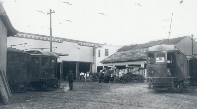
Vehicles with different levels of horsepower at old Boston trolley barn
New commenting turned off as we begin the Great UHub Migration. Back later today.
By adamg on Wed, 04/21/2021 - 11:20am
Ad:
Support Universal Hub
Help keep Universal Hub going. If you like what we're up to and want to help out, please consider a (completely non-deductible) contribution.
Comments
Bartlett Yd?
Bartlett Yd?
Perhaps
The facility that used to be located on South Street (near McBride) in JP, where there are now housing projects?
The trolley freight terminal
The trolley freight terminal at Copps Hill Wharf in the North End that was destroyed when the molasses tank exploded.
back bay
station
Arborway?
Arborway?
Some Hints...
This is NOT a passenger station...
This yard and facility was accessed via some of the final remaining surface streetcar trackage within Downtown Boston...
Trolleys were dispatched from here before dawn to points as far away as Worcester, Springfield and Woronoco...
literally no idea
Literally no idea.. but just a stab in the dark.. somewhere in Bay Village. Maybe where the housing complex is now? Makes sense considering the portal for the tunnels was nearby.
Somewhere on or near Huntington Avenue?
Long before the Mass Pike was built, Route 9 (Worcester Turnpike) was the way to get to those places from Boston. There were streetcar tracks alongside Route 9 in the suburbs and beyond.
Interesting!
I had no idea this existed! Those are obviously not BERy cars but interurbans or freight vehicles. Now I'm trying to figure out the routing. I assume they ran over to North Station and into the subway, before popping out at the Public Garden and following the Huntington Avenue Line to the Worcester Turnpike.
Thanks for playing, folks!
Thanks for playing, folks! This photo is Copps Hill Wharf and was taken on December 6, 1917.
And just out of view to the right...
The molasses tank, which had been erected in 1915, would have been just out of the view of this photo, just to the right of the trolley car in the foreground. I think you can see the tank's shadow on the ground at far right.
The tank itself was built and owned by Purity Distilling, but was on land leased from the Boston Elevated Railway. The tank was adjacent to the street and sidewalk; the buildings shown here were out on the pier.